A city is difficult to drive in when several pressures overlap: traffic takes a long or unpredictable time, street layouts create confusing or high-conflict maneuvers, people outside cars share limited space, and temporary changes such as road work remove normal routes or lanes. A place can feel exhausting because it is slow, stressful, or unsafe—or because all three occur together.
There is no defensible worldwide formula that produces one ranking of the hardest cities to drive in. The Federal Highway Administration (FHWA) measures congestion and reliability across 54 U.S. urban areas, while World Health Organization (WHO) sources describe road safety globally without publishing a comparable city-by-city driving-difficulty index. The useful approach is to examine each city across the conditions that shape a driver’s actual trip.
As an Amazon Associate I earn from qualifying purchases.
What does “difficult to drive in” actually mean?
Driving difficulty is broader than a low average speed. A driver may complete a trip quickly but face confusing turns, poor sight lines, frequent conflicts with pedestrians and cyclists, or abrupt lane changes. Conversely, a familiar, well-marked road can be tolerable even when it is congested if its travel time is predictable and the route remains legible.
What’s actually slowing this PC down?
Pick the symptom - the matching free tool is one click away.
Four dimensions explain most of the experience:
- Congestion: how much travel time is lost.
- Reliability: how much the same trip varies by hour, day, weather, or incident.
- Street design and planning: whether the road network makes movements clear and manages conflicts safely.
- Exposure and disruption: how many people are sharing the road and how often construction or other temporary changes constrain it.
These dimensions interact. A narrow work zone on a busy commercial street may slow cars, push drivers toward unfamiliar detours, and bring vehicles closer to people walking or cycling. A wide arterial may move traffic quickly yet remain difficult because intersections are complicated and crossing activity is heavy.
#1 Best Overall

- UPSCALED 4K FRONT + 1080P REAR DUAL DASH CAM: The ROVE R2-4K DUAL records the road ahead and behind at the same time. The front camera captures at 2.5K (QHD) and intelligently upscales to 4K (2160P) for higher-detail playback, while the rear camera records at Full HD 1080P. This is upscaled 4K, not native 4K, engineered to show sharper everyday detail than standard 1080P dash cams, so you can read license plates, signs, and surroundings in front and rear footage.
- SONY STARVIS 2 IMX675 SENSOR + SUPER NIGHT VISION: The front camera uses a Sony STARVIS 2 IMX675 5MP image sensor with a wide F1.5 aperture (F1.8 rear) and HDR to pull in more light for clearer low-light footage. This advanced sensor enhances nighttime clarity, helping capture license plates, road signs, and surrounding vehicles with greater reliability when driving after dark, through tunnels, or in dusk and dawn conditions.
- ULTRA FAST 5.8GHz WIFI/ UP TO 20MB/s DOWNLOAD SPEED: With its built-in dual-band 5.8GHz and 2.4GHz WiFi, you can use the ROVE dash cam app to view and manage dash cam recordings instantly on your iPhone and Android smartphone. Using the ROVE app, download your recorded videos directly to your smartphone at up to 20 MB/sec, then easily share them on social media with friends and family. Additionally, manage camera settings and update the latest firmware over-the-air via the ROVE App.
- CAR CAMERA WITH GPS: The new front and rear dashcam comes with built-in GPS, which enables you to view real-time live speed and compass on the 3” IPS wide camera screen. It records precise driving routes, locations, and speed stamps directly on the video so you can watch dashcam videos with GPS data using ROVE's free GPS Player on your PC or Mac & get additional evidence when you need it.
- FEATURES WITH STATE-OF-THE-ART TECHNOLOGY INCLUDED: Experience peace of mind with this front and rear car dash cam. It comes with a free 128GB microSD card and offers advanced features such as an f1.5 aperture, motion detection, G-sensor, seamless loop recording, emergency video lock, screen saver, live speed and compass direction, voice guidance, ring of threads for optional CPL filter, a built-in supercapacitor for extended product life, support for up to 1TB microSD cards, and many more.
Congestion: the time cost of a trip
Average delay is only the starting point
Congestion is easiest to recognize when a journey takes longer than it would under free-flow conditions. The FHWA’s Quarterly Urban Congestion Report tracks recent congestion and reliability trends using vehicle-probe travel-time data weighted by traffic volumes across 54 U.S. urban areas. Its current page includes data through April–June 2026. Because the program is U.S.-specific, its figures should not be treated as a global city ranking. FHWA Quarterly Urban Congestion Report
Averages can hide the experience of individual trips. A corridor that moves at a reasonable speed most of the day may become nearly stationary during a short peak period. A driver who must arrive at a fixed time experiences that peak, not the daily average.
Reliability determines whether planning is possible
Two routes with the same average travel time can feel completely different if one varies widely. Unpredictable queues, crashes, signal changes, weather, or recurring bottlenecks force drivers to add large time buffers and still risk being late. FHWA explicitly notes that “travel time is a more direct measure of how congestion affects users” than measures such as level of service. FHWA congestion and reliability reports
For a meaningful comparison, ask both how long a representative trip takes and how much that time changes. A city with moderate but consistent delay may be easier to navigate than one with a shorter average trip and frequent severe outliers.
Street design and planning create or reduce conflict
Legibility and maneuver complexity
Drivers need to understand where lanes go, which movements are permitted, and who has priority. Difficult environments can include closely spaced intersections, offset junctions, short merge areas, irregular one-way systems, turn restrictions, or signs that appear after a decision point. These features increase the chance of late lane changes, missed turns, sudden stops, and route diversions.
Complexity is not automatically unsafe; a clearly marked grid can handle many movements. The issue is whether road geometry, signs, signals, and markings give every road user enough time and space to act predictably. A route that is technically navigable may still impose high mental workload when several decisions arrive at once.
Rank #2

- 💖💖【Important Note】Due to soaring memory chip costs, many brands have eliminated memory cards entirely, requiring a separate purchase. However, to save you the hassle of buying extra accessories, we are resisting cost pressures without raising our dashcam's price. Starting June 26, 2026, this camera will include a 32GB memory card (previously 64GB) so you can still use it out of the box. For extended storage, we highly recommend purchasing a Class 10, U3, and V30 (or higher) memory card.
- 【4K 2160P Resolution Dash Cam】Capture every drive in stunning 4K UHD resolution with the Galphi front dash cam, featuring a 160-degree wide-angle lens for clear, cinematic video footage. Ideal for family cars, new drivers, and Uber/Lyft drivers, it provides reliable video evidence for accident disputes and insurance claims.
- 【Advanced 5GHz WiFi with App】 Featuring cutting-edge 5GHz WiFi and a free app, the video download speed reaches up to 8MB/s, compared to just 2MB/s with the 2.4GHz option. This greatly reduces download times and minimizes lag during video playback.
- 【No Screen & Less Distraction】This dash camerma features a screen-free design, minimizing distractions while you drive so you can stay focused on the road. Enjoy peace of mind knowing your camera is recording without taking your attention away from the journey.
- 【Compact and Super Easy to Install】The dash cam's slim and compact design ensures it won't obstruct your view. With easy installation and clear, detailed instructions included, even first-time users can set it up without any hassle.
Land use determines who is in the street
Transport and land-use planning shape the number and type of interactions a driver encounters. Dense destinations, schools, transit stops, loading activity, and commercial entrances bring more crossings and turning movements. Long blocks and limited crossing points can concentrate pedestrians at particular locations. A street designed only to move cars may perform poorly when it also serves as a place to walk, cycle, shop, wait for transit, and load goods.
The WHO identifies safer infrastructure and the incorporation of road-safety features into land-use and transport planning as effective interventions. Its statement is broader than a city-design ranking, but it establishes why planning belongs in any explanation of driving difficulty: WHO road traffic injuries fact sheet.
Safety includes people outside the vehicle
Vulnerable road users change the risk picture
Occupant protection is only one part of road safety. The WHO reports that more than half of road traffic deaths are among vulnerable road users, including pedestrians, cyclists, and motorcyclists. In a city, drivers frequently share space with these groups at crossings, intersections, curbside activity, bike facilities, and mixed-traffic streets. Their presence does not make a city intrinsically bad to drive in; it means that speed, visibility, yielding, and lane positioning matter to people who have much less physical protection than someone inside a car.
High exposure can make a trip stressful even when collisions are infrequent. Drivers must scan more often, anticipate a person emerging from between parked vehicles, and account for two-wheeled users who may occupy different parts of the roadway. For pedestrians and cyclists, the same environment may be difficult or dangerous from the opposite perspective. A complete assessment therefore considers the safety of everyone using the street, not just vehicle delay.
Design features influence how errors unfold
Clear crossings, readable lane assignments, appropriate speeds, lighting, separation where needed, and predictable signal operation can reduce the consequences of an inevitable mistake. The available WHO guidance supports treating these features as part of infrastructure and planning, but it does not supply a universal checklist that can score every city. Claims about a particular design should therefore be tied to the location, road users, and time period being examined rather than presented as a global rule.
Free tools Windows power users keep installed
One-click scans. No signup required.
Work zones and other temporary disruptions
Why construction changes the normal driving task
Road work can make a familiar route suddenly unfamiliar. The FHWA describes work zones as places where traffic patterns change and the available right-of-way narrows; those conditions can contribute to crashes and delay. FHWA work-zone information
Rank #3
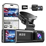
- [4K+1080P Front & Rear Recording] REDTIGER F7NP dash cam captures every detail with stunning 4K front and 1080P rear video. Featuring the advanced STARVIS 2 sensor plus the 170° front and 140° rear wide-angle lens, this dash camera delivers sharper images, balanced lighting, and reliable evidence day or night. Ideal for commuting, road trips, rideshare drivers, and new drivers.
- [STARVIS 2 Sensor & WDR Night Vision] Equipped with the advanced STARVIS 2 sensor, F1.5 large aperture, and 6-layer optical lens, F7NP 4K dual dash cam delivers clear, high-contrast footage in any lighting. WDR and HDR technology balance highlights and shadows, ensuring sharp night vision and crisp details day or night, providing reliable evidence and enhanced safety for every drive.
- [Built-in 5.8GHz WiFi & Smart App] Connect your smartphone to the dashcam’s built-in 5.8GHz WiFi to enjoy ultra-fast downloads up to 20MB/s. Using Redtiger Cam app, you can preview, download, and replay videos in real time, check GPS ata (route, speed, and location), and manage settings effortlessly, making it simple to review footage and share important moments.
- [Loop Recording & Free Memory Card] This car camera supports seamless loop recording to ensure continuous coverage without interruption. Older files are automatically overwritten when storage is full, while important events are safely locked. A free memory card is included, giving you ample space for 4K recordings and allowing you to use the camera right out of the box.
- [24/7 Parking Mode* & G-Sensor] Enjoy round-the-clock protection with two parking modes: time-lapse recording for continuous low-bitrate monitoring and G-sensor mode that records when collision is detected. The car security camera with G-sensor automatically locks important clips, ensuring crucial evidence is safely preserved even while your vehicle is parked.(*Hardwire kit needed.)
Temporary difficulty comes from more than a closed lane. Barriers can move the edge of the roadway, lanes may shift overnight, signs can be concentrated in a short distance, and workers or equipment may be close to moving traffic. A detour can add intersections and turns to a route that drivers previously knew by memory. Delays may also spill onto nearby streets, making a normally quiet road part of a temporary diversion.
How to account for disruptions in a comparison
State whether a city comparison covers a normal period or includes a major construction project, event, emergency, or weather episode. A snapshot taken during one project is not evidence that the entire network is permanently difficult. Conversely, recurring maintenance and frequent lane closures are part of the practical driving environment and should not be dismissed as anomalies if they affect everyday trips.
How the factors interact on a single trip
Consider a central avenue during the afternoon peak. Traffic volume produces a queue approaching an intersection. A work zone removes one through lane, so vehicles merge earlier and the queue extends into the previous block. A bus stop and a marked crossing bring pedestrians into the narrowed section. Drivers who miss a turn face a one-way detour and must circle the block. The result is not one problem but a chain:
Recommended Free Tools
- Reduced capacity increases delay.
- The lane closure makes travel time less reliable.
- Merging and narrowed space increase the number of conflict points.
- Crossing activity raises the need for careful speed and observation.
- The detour adds decisions and unfamiliar movements.
Removing any one pressure may improve the trip, but the combined effect explains why a city can feel substantially harder to drive through than a city with the same nominal traffic volume.
Independent reader supportYour contribution helps us test, update, and keep practical guides available for everyone.How to compare two cities without misleading yourself
Start by defining the comparison. Name the geography (city limits, metropolitan area, or a specific corridor), the period, the trip type, and the metrics. Congestion and reliability data cannot be substituted for safety outcomes, and a global casualty estimate cannot rank individual city streets.
| Question | Useful measure or observation | What it tells you |
|---|---|---|
| How slow is traffic? | Travel time or delay for a defined route and time window | The time cost experienced by drivers |
| How predictable is the trip? | Variation in travel time across comparable days and times | How much buffer a driver needs |
| How understandable is the network? | Lane continuity, sign timing, turn rules, intersection spacing, and detour clarity | The mental and maneuvering workload |
| Who shares the road? | Pedestrian, cyclist, and motorcyclist activity at crossings, junctions, and curb space | The level of interaction and safety exposure |
| What is temporary? | Active work zones, closures, event controls, and changing traffic patterns | Whether current difficulty reflects a disruption or a lasting condition |
FHWA’s U.S. congestion program can inform the first two questions for the urban areas it covers. WHO’s global road-safety material establishes the importance of infrastructure and vulnerable road users, but it does not provide equivalent city-level scores for the table’s other rows. A responsible article or travel plan should label those observations as local or corridor-specific rather than combining unlike figures into a single number.
Rank #4

- 【1296P front recording and night vision】 The V300 front dash cam records in 2304 x 1296P to capture everyday road details with greater clarity than standard 1080P. A 170° wide-angle lens covers multiple lanes, while the F1.7 aperture and 6-layer glass lens help improve visibility during nighttime driving and other low-light conditions.
- 【WiFi app control 】Connect your phone to the dash camera’s built-in Wi-Fi and use the VeeCar app to preview live video, play back recordings, download clips, and share files. The Wi-Fi connection is local and does not provide internet access; this dash camera for cars still requires a power cable during use.
- 【Advanced Safety Engineering】Designed with your safety in mind, Veement V300 mini dash cam incorporates an RTC circuit and eliminates traditional lithium batteries to prevent overheating. This dedication to safety guarantees reliable performance under various conditions, requiring only a continuous USB-C power supply.
- 【Seamless Connectivity & Easy Operation】Utilize the built-in WIFI and exclusive VeeCar APP to effortlessly control your WiFi front dash cam. From real-time previews to straightforward video downloads, edits, and shares, Veement V300 dash camera for cars offers an intuitive interface for managing your driving footage.
- 【Advanced Features for Complete Protection】Take advantage of cutting-edge TS stream technology in this WiFi dashcam for fast and reliable video storage. Supporting up to 256GB SD cards, seamless loop recording, and 24/7 parking mode, Veement V300 car dash cam provides comprehensive security. Its user-friendly operation ensures a seamless experience. (Note: SD card not included, must be purchased separately).
Why traffic scores and safety scores should stay separate
A congestion index answers a mobility question: how much time does movement consume, and how dependable is it? A crash or fatality measure answers a safety question: how often do serious injuries or deaths occur, and which road users are affected? They are related because speed, exposure, and design can influence both, but they are not interchangeable.
A city may have slow traffic and relatively low speeds in dense areas while still requiring careful attention at crossings. Another may have fast, free-flowing arterials with severe consequences when a mistake occurs. Reporting one as “harder” requires stating whether the criterion is delay, predictability, maneuver complexity, perceived stress, collision risk, or a defined combination. Without that definition, different rankings can appear to disagree while measuring different things.
Global road-death figures: important context, not a city ranking
The WHO’s road traffic injuries fact sheet, dated 20 July 2026, estimates approximately 1.16 million people die each year in road traffic crashes worldwide. It also states that more than half of deaths are among vulnerable road users. These are global safety estimates, not measurements of how long it takes to drive through a particular city.
A separate WHO Global status report on road safety 2023 reported 1.19 million annual road traffic deaths, covering progress from 2010 to 2021. The two numbers come from different publications and reporting frames. They should not be presented as a single time series or used to imply that one city is safer or harder to drive in than another without city-level evidence.
Practical ways to reduce difficulty on a real city trip
Before leaving
- Check the expected travel time for the actual departure window, not just the route’s free-flow estimate.
- Look for active lane closures, event restrictions, and detours along the route.
- Identify decision points—complex interchanges, one-way sections, and turns that cannot be repeated easily—before entering them.
- Allow a buffer when reliability is poor; a short average trip can still have large day-to-day variation.
While driving
- Reduce speed early when lanes narrow, markings change, or people are crossing.
- Make lane choices before the final sign or exit rather than forcing a late merge.
- Expect pedestrians, cyclists, and motorcyclists near crossings, transit stops, driveways, and curbside loading.
- In a work zone, follow the temporary signs and markings rather than relying on memory of the normal road layout.
- If a turn is missed, continue safely and use the next legal route; abrupt stopping or reversing creates a new hazard.
After the trip
Separate what was a network characteristic from what was a one-off event. Record the route, time, weather, active works, and unusual incidents if you are evaluating a commute or planning repeated travel. That simple log produces a more useful picture than a single anecdotal journey.
The bottom line
A city is difficult to drive in when delay, unpredictability, complex design, interaction with unprotected road users, and temporary constraints reinforce one another. The fairest assessment defines the place and time, measures travel time and reliability, describes how the street works for all users, and identifies disruptions. Official evidence supports these dimensions, but it does not support a universal global ranking of the hardest cities to drive in.
Quick Recap
Product prices and availability are accurate as of the date/time indicated and are subject to change. Any price and availability information displayed on Amazon at the time of purchase will apply.




