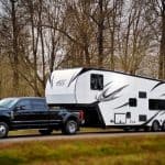
The TransAmerica Trail has always been more than a line on a map. Stretching roughly 5,900 miles from the Atlantic coast of North Carolina to the Pacific shoreline of Oregon, it’s a stitched-together network of dirt roads, forest service tracks, high-desert two-lanes, and forgotten county routes that reward mechanical sympathy and good navigation more than raw horsepower. Built by riders and drivers who valued self-reliance over convenience, it became a rite of passage for overlanders long before landing a vehicle at Moab or the Rubicon went mainstream.
From Hand-Drawn Routes to a National Overland Backbone
What made the TransAmerica Trail legendary wasn’t just its length, but its accessibility. You didn’t need locking diffs, massive suspension travel, or triple-digit torque figures to run it; a well-prepped midsize truck or adventure motorcycle and a disciplined approach to tire pressure and load management were enough. That grassroots DNA turned it into a living route, evolving with seasonal washouts, land access changes, and local knowledge passed between travelers.
Yet that same organic nature also made it fragile. Navigation relied on GPX files, paper atlases, and word-of-mouth updates, which meant missed turnoffs, dead ends, or worse, trespassing onto restricted land. For years, the biggest limiter wasn’t vehicle capability or fuel range, but information accuracy.
Why Street View Changes the Game for Overlanders
By bringing the TransAmerica Trail into Google Street View through a Ford and Google collaboration, that information gap narrows dramatically. Street-level imagery allows drivers to preview surface conditions, road width, camber, and even potential bypasses before ever dropping into 4H. It’s the difference between guessing if a washed-out section will swallow a long-wheelbase truck and knowing whether your approach angle and ground clearance are up to the task.
For expedition planners, this transforms risk management. You can assess whether a route favors a solid rear axle setup over independent suspension, anticipate where airing down is mandatory, or identify sections that may stress cooling systems under sustained low-speed load. It’s not about sanitizing the adventure; it’s about making informed decisions that protect vehicles and travelers alike.
Vehicle-Mounted Mapping Tech and the Future of Exploration
The fact that this mapping is vehicle-mounted matters as much as the imagery itself. Modern sensor suites, stabilized camera rigs, and GPS-integrated data capture mean the trail is documented from the same perspective drivers experience it, not from a drone or satellite. That aligns perfectly with where connected vehicles are headed, blending navigation, terrain awareness, and real-world conditions into a single interface.
For overlanders, this signals a future where planning a cross-country dirt route feels as intuitive as setting up a daily commute, without stripping away the challenge. For automakers like Ford, it reinforces the idea that trucks and SUVs are no longer just mechanical tools but rolling data platforms. And for the TransAmerica Trail, it marks a turning point, evolving from a word-of-mouth overland secret into a digitally preserved corridor of American adventure.
Inside the Ford–Google Partnership: How Automaker and Tech Giant Aligned on Adventure Mapping
The leap from concept to execution required more than cameras and corporate logos. Ford and Google aligned because each brings a complementary strength: Ford understands how vehicles behave when pavement ends, while Google knows how to turn raw spatial data into usable navigation intelligence. The TransAmerica Trail became the proving ground where mechanical durability and digital precision intersect.
Why Ford Was the Right Automaker for the Job
Ford’s off-road credibility isn’t marketing fluff; it’s baked into frame design, suspension travel, and powertrain calibration. Platforms like the Bronco and Ranger are engineered to survive sustained vibration, heat soak at low speeds, and repeated articulation events that would cripple a standard road car. That matters when you’re strapping sensitive camera arrays and GPS hardware to a vehicle expected to crawl through mud, sand, and high-altitude passes for thousands of miles.
Equally important, Ford’s experience with fleet telematics and over-the-air software gave Google a vehicle partner already fluent in data capture. These trucks weren’t just driving the trail; they were measuring it in real time, correlating imagery with vehicle speed, pitch, roll, and precise geolocation. That’s how Street View gains context, not just pictures.
Google’s Mapping Stack Meets Real-World Terrain
Google Street View has long excelled in urban and suburban environments, but the TransAmerica Trail demands a different approach. Off-road routes lack lane markings, signage, and consistent surfaces, forcing Google’s mapping algorithms to rely heavily on vehicle-mounted sensors and high-resolution visual stitching. The result is a trail rendered as it actually exists, complete with ruts, elevation changes, and surface transitions that satellites often flatten or miss entirely.
For overlanders, this is the critical shift. Instead of abstract lines on a topo map, you get a driver’s-eye perspective that reveals whether a section is graded gravel or embedded rock, wide enough for a full-size pickup or better suited to a short-wheelbase rig. It’s actionable intelligence, not just visual curiosity.
Vehicle-Mounted Mapping as a Glimpse of Connected Futures
What makes this partnership especially significant is how closely it mirrors the future of connected vehicles. The same systems used to map the TransAmerica Trail can feed next-generation navigation, trail condition updates, and even predictive route guidance based on vehicle capability. Imagine a navigation system that knows your truck’s ground clearance, tire size, and cooling capacity, then flags sections where mechanical sympathy matters most.
This collaboration signals that automakers and tech companies are no longer operating in parallel lanes. They’re co-developing tools that treat vehicles as mobile data platforms, capable of expanding our understanding of where we can go and how safely we can get there. For adventure travelers, that means the next evolution of exploration won’t replace skill or judgment, but it will give them sharper tools before the first tire ever leaves pavement.
Mapping the Unmapped: Vehicle-Mounted Cameras, Off-Road Data Capture, and Street View Beyond Pavement
If the earlier sections established the why, this is the how. Mapping a 5,900-mile route that deliberately avoids pavement requires abandoning assumptions baked into urban mapping. Ford and Google had to rethink what a “Street View car” even is when the street disappears.
Purpose-Built Rigs for Terrain That Fights Back
Unlike city-based Street View vehicles, the TransAmerica Trail demanded trucks engineered for sustained off-highway travel. High-clearance Ford platforms, equipped with reinforced suspensions, all-terrain tires, and skid protection, were critical simply to survive the route. The goal wasn’t speed or comfort, but stability and consistency across thousands of miles of gravel, sand, mud, and rock.
Camera arrays were mounted higher than typical Street View cars to maintain sightlines over brush, erosion berms, and uneven terrain. That elevated perspective helps preserve horizon reference points, which are vital when stitching imagery across surfaces that lack straight edges or predictable geometry. In off-road mapping, camera placement is as much about chassis dynamics as optics.
Capturing More Than Images: Terrain Data in Motion
What separates this effort from traditional trail photography is data density. As the vehicles crawled across passes and desert flats, they logged GPS position, speed, yaw, pitch, and roll alongside every frame of imagery. That sensor fusion allows Google to align visuals with the physical reality of the trail, not a smoothed approximation.
For overlanders, this matters because trails are three-dimensional problems. A mild-looking path can hide cross-axle articulation challenges or steep breakover angles that only become obvious when elevation data and camera perspective agree. Street View on the TransAmerica Trail doesn’t just show you where the road goes; it hints at how your vehicle will behave when you follow it.
Why Satellites Fall Short and Wheels Matter
Satellite imagery struggles in exactly the environments the TransAmerica Trail thrives in. Tree cover obscures paths, seasonal changes alter surfaces, and shadows flatten depth perception. Vehicle-mounted mapping fills those gaps by operating at trail level, capturing what tires and suspension actually encounter.
This is especially critical in transitional zones where the trail shifts from graded county road to unmaintained two-track without warning. Street View imagery exposes those transitions clearly, giving travelers a chance to assess whether their rig, from tire load rating to cooling capacity, is suited for what’s ahead. It’s the difference between theoretical access and practical passage.
Street View as a Tool for Pre-Trip Mechanical Judgment
Bringing the TransAmerica Trail into Street View reframes it as a planning instrument, not just a visual archive. Overlanders can now scout choke points, narrow bridges, washouts, and surface changes months before departure. That directly informs decisions on suspension setup, spare parts, fuel range, and even whether to bring a second vehicle.
Zoomed-in imagery can reveal ruts deep enough to test differential clearance or long stretches of corrugation that punish shocks and mounts. For drivers who take mechanical sympathy seriously, this kind of preview is invaluable. It allows preparation rooted in evidence rather than forum hearsay.
A Preview of Navigation That Understands Capability
This off-road Street View push hints at where connected navigation is headed. When visual data is tied to vehicle telemetry and mapped at scale, navigation can evolve from route finding to capability matching. The same datasets used here could one day warn drivers that a fully loaded full-size truck may struggle in a tight, off-camber section designed for lighter rigs.
Ford and Google mapping the TransAmerica Trail isn’t just about documenting a legendary route. It’s about teaching digital maps to respect terrain, physics, and machinery. For anyone who plans adventures beyond the pavement, that shift changes how trips are planned long before the engine ever turns over.
What Overlanders Gain: Virtual Recon, Route Planning, and Risk Reduction on a 5,900-Mile Trail
Virtual Recon at Tire Height, Not Satellite Altitude
What changes immediately is perspective. Street View captured by Ford vehicles runs at eye level for an axle, not a satellite, exposing camber, crown, erosion lines, and vegetation encroachment that aerial imagery simply flattens away. Overlanders can finally read the trail the way a suspension does, understanding where articulation is required and where body damage becomes a real possibility.
This matters on a 5,900-mile route that crosses deserts, forests, farmland, and mountain passes. The TransAmerica Trail is not static, and vehicle-mounted imagery shows how weather and use reshape it season by season. That kind of recon used to require weeks of scouting or blind faith; now it happens from a laptop.
Route Planning That Respects Real-World Constraints
With Street View stitched along the TAT, route planning shifts from line-drawing to decision-making. Overlanders can identify bypasses around mud-prone valleys, spot alternate county roads for heavy rigs, or confirm whether a two-track widens enough to allow a full-size truck to turn around. It’s planning with context, not just coordinates.
Fuel strategy also improves. Visual confirmation of long, empty stretches informs tank size, auxiliary fuel needs, and resupply intervals. When you can see where towns thin out and terrain slows average speed, range anxiety becomes a solvable equation instead of a guessing game.
Mechanical Risk Reduction Before the First Mile
The biggest gain may be what never breaks. By previewing surface conditions, overlanders can anticipate shock fade on corrugation, overheating risks on sustained climbs, or underbody exposure in rocky sections. That foresight drives smarter prep, from bump stop tuning and skid plate selection to choosing tires with the right sidewall construction.
It also reduces recovery risk. Knowing where a trail narrows, drops into a wash, or crosses soft ground helps travelers avoid committing to sections where extraction would be complex or dangerous. Risk management starts long before traction control ever intervenes.
A New Baseline for Shared Trail Intelligence
Because this data lives inside Google’s ecosystem, it becomes a common reference point. Trail conditions, access roads, and transitions are no longer described vaguely; they’re visible, shared, and verifiable. That elevates the quality of trip planning across the entire overlanding community.
More importantly, it signals how connected vehicles will shape future adventure travel. As Ford’s vehicle-level mapping merges with Google’s platform, the trail itself becomes a data source, teaching navigation systems to understand not just where to go, but whether a given vehicle should. For overlanders, that’s not convenience. It’s capability awareness, finally rendered in pixels.
Connected Vehicles and the Future of Navigation: What This Project Signals for Off-Road Tech
What makes the TransAmerica Trail appearing on Google Street View truly disruptive isn’t just visibility. It’s the proof that production vehicles, operating in harsh off-road environments, can now act as mobile data collectors for global navigation platforms. This project is a real-world demonstration of connected vehicles shaping how trails are understood, routed, and ultimately driven.
From Passive Maps to Vehicle-Aware Navigation
Traditional navigation treats every road as equal until it fails you. Connected navigation flips that logic by factoring in vehicle capability, surface type, and environmental context before the route is ever chosen. By mapping the TAT with vehicle-mounted camera systems, Ford and Google are teaching navigation software the difference between pavement, gravel, rutted two-track, and seasonal access roads.
This matters because future routing won’t just ask where you want to go. It will ask what you’re driving, how it’s equipped, and whether your platform has the clearance, cooling capacity, and traction systems to get there safely. For off-roaders, that’s a fundamental shift from guesswork to informed decision-making.
How Vehicle-Mounted Mapping Changes the Data Itself
Unlike satellite imagery, vehicle-mounted Street View captures perspective at ride height, moving at trail speed. That means washboard severity, camber changes, vegetation encroachment, and sightlines through corners are recorded as a driver actually experiences them. For overlanders, this visual fidelity is the difference between theoretical access and practical drivability.
It also captures transitions that maps usually miss. Pavement to dirt, dirt to rock, maintained county road to abandoned track. These transitions are often where heavy rigs struggle, where tire pressure decisions matter, and where drivetrain heat starts to build.
The Rise of Predictive Off-Road Navigation
Once this type of trail data feeds into connected vehicle systems, navigation stops reacting and starts predicting. A future Ford Bronco or Ranger doesn’t just know it’s on the TransAmerica Trail; it understands what that section typically demands from suspension travel, cooling systems, and traction control. That opens the door to adaptive route guidance that suggests slower alternatives, warns of sustained load, or reroutes based on recent weather patterns.
For drivers, that intelligence reduces fatigue and mechanical stress. For the vehicle, it means systems like terrain management, transmission mapping, and even hybrid power distribution can be optimized before conditions deteriorate.
What This Signals for the Next Generation of Adventure Vehicles
This partnership hints at a future where off-road capability is as much software-driven as hardware-defined. Locking differentials and skid plates still matter, but so does how well your vehicle understands the terrain ahead. The TransAmerica Trail becoming part of Google’s Street View ecosystem shows that manufacturers are no longer content to leave adventure navigation to third-party apps and forum anecdotes.
Instead, the trail itself becomes part of the vehicle’s operating environment. For overlanders and adventure motorists, that means planning, driving, and adapting with a level of clarity that simply wasn’t possible before connected vehicles began learning directly from the dirt.
Real-World Implications for Trail Access, Land Use, and Responsible Overlanding
The moment the TransAmerica Trail becomes visible in Google Street View, it stops being folklore and starts being verifiable infrastructure. That shift carries real consequences for who uses the trail, how it’s managed, and how responsibly it’s driven. This isn’t just about seeing the route; it’s about redefining the relationship between vehicles, land, and access.
Clarifying Legal Access and Reducing Guesswork
One of the biggest pain points in overlanding has always been uncertainty around legal access. Paper maps go stale, forum posts conflict, and a locked gate can turn a day’s plan into a liability issue. Street View imagery tied to verified routing gives drivers visual confirmation of signage, easements, and road character before a tire ever touches dirt.
For full-size trucks and heavily built rigs, that matters. Knowing whether a section is a maintained county road or a narrow two-track through mixed-use land directly affects vehicle choice, trailer feasibility, and turnaround planning. It reduces accidental trespass, which has historically been one of the fastest ways to lose trail access altogether.
Land Use Transparency for Agencies and Communities
From a land management perspective, this level of visibility cuts both ways. Federal agencies, state land offices, and local municipalities gain a clearer picture of how routes are being used, what types of vehicles are traveling them, and where wear is accelerating. That data can inform maintenance schedules, seasonal closures, and reroutes before damage becomes irreversible.
For rural communities along the TransAmerica Trail, the implications are just as significant. Increased exposure can drive tourism and economic activity, but it also raises the stakes for traffic management and environmental stewardship. When everyone can see the trail, pressure increases to manage it correctly, not just keep it open.
Raising the Bar for Responsible Overlanding
Street-level visibility changes driver behavior, whether we like it or not. When a route is documented in detail, there’s less excuse for bypassing obstacles, creating illegal spurs, or ignoring posted restrictions. The trail becomes a shared, observable resource rather than a loosely defined adventure corridor.
This dovetails with Ford’s interest in building vehicles that actively guide responsible use. When navigation systems understand terrain sensitivity, weather impact, and historical degradation, they can steer drivers away from vulnerable sections during high-risk periods. That’s not nanny tech; it’s preserving access by aligning driver behavior with land realities.
A New Accountability Loop Between Driver, Vehicle, and Terrain
The Ford–Google partnership effectively closes the loop between exploration and accountability. Vehicles collect data, mapping platforms contextualize it, and drivers make better-informed decisions as a result. Over time, that feedback loop encourages smarter route choices, fewer recoveries, and less trail damage.
For the overlanding community, this represents a cultural shift. Capability is no longer just about horsepower, torque curves, or suspension articulation; it’s about understanding where and how to deploy that capability responsibly. As the TransAmerica Trail enters the Street View era, access increasingly depends on how well drivers respect what the camera reveals.
How This Changes Adventure Travel Planning: From Desktop Scouting to In-Vehicle Navigation
What accountability changes on the trail, it also transforms long before the engine fires. By bringing the TransAmerica Trail into Google Street View, Ford and Google have effectively collapsed the gap between armchair planning and real-world execution. The result is a new planning workflow where uncertainty is replaced by visual context, and improvisation becomes informed decision-making rather than blind trial and error.
Desktop Recon Goes From Guesswork to Visual Intelligence
For decades, overlanders have relied on forum posts, GPX tracks, and grainy trail photos to understand what lay ahead. Street View changes that equation by letting you visually inspect surface conditions, trail width, water crossings, and exposure from your laptop or phone. You can see if a “road” is actually a two-track with encroaching brush, or if a supposed bypass has become a braided mess of tire scars.
That level of detail matters when you’re matching route difficulty to vehicle capability. A stock Bronco Sport, a Sasquatch-equipped Bronco, and a full-size F-150 Tremor all play in different envelopes of ground clearance, breakover angle, and approach geometry. Street-level imagery lets you plan accordingly instead of discovering mismatches miles from pavement.
Vehicle-Mounted Mapping Turns Cameras Into Co-Drivers
What makes this partnership more than just a desktop novelty is how the data is collected and deployed. Ford’s vehicle-mounted camera systems capture the trail at driver height, under real conditions, with suspension movement, sightlines, and terrain scale intact. That perspective is far more relevant than satellite imagery when you’re judging ruts, ledges, or off-camber sections.
Once integrated into Google’s mapping ecosystem, that data becomes actionable inside the vehicle. Navigation isn’t just routing anymore; it’s context-aware guidance that understands trail character. When your in-dash system knows what the road actually looks like, it can help you anticipate obstacles before they’re in your windshield.
From Static Routes to Adaptive Navigation
The real leap forward is how this data enables adaptive planning. Instead of locking in a rigid route weeks in advance, drivers can adjust plans dynamically based on what the trail looks like now. Washed-out sections, seasonal closures, or reroutes stop being surprises and start being variables you can manage.
As connected vehicles ingest live updates, weather overlays, and historical trail data, navigation evolves into a decision-support system. That’s especially critical on a 5,900-mile route where conditions in Utah bear no resemblance to those in Mississippi. The trail stops being a single line on a map and becomes a living network.
Planning Becomes Part of the Driving Experience
This is where the future of adventure travel planning gets interesting. The boundary between planning and driving starts to dissolve as in-vehicle systems offer the same visual intelligence once reserved for pre-trip research. You’re no longer switching between paper maps, apps, and memory; the vehicle becomes the hub that ties it all together.
For overlanders, that signals a shift in mindset. Preparation isn’t just about spare parts and fuel range anymore; it’s about data fluency. As Ford and Google bring the TransAmerica Trail into Street View, they’re redefining how exploration is planned, navigated, and executed, with the vehicle itself becoming an active participant in the adventure rather than just the tool that gets you there.
What Comes Next: Expanding Off-Road Mapping, OEM Partnerships, and the Digitization of Adventure Routes
What Ford and Google have done with the TransAmerica Trail is less a one-off project and more a proof of concept. By proving that a 5,900-mile, mixed-surface route can be captured at trail level and integrated into a global mapping platform, they’ve established a new baseline for what off-road navigation can be. The question now isn’t whether this expands, but how fast and how far it goes.
From a Single Trail to a Global Off-Road Network
The TransAmerica Trail is the opening move, not the endgame. Once the capture hardware, data pipelines, and validation processes are in place, scaling to other iconic routes becomes straightforward. Think the Backcountry Discovery Routes, Mojave Road, Alpine passes, and international overland corridors that have historically lived in GPX files and word-of-mouth lore.
Street View-level trail data changes how these routes are understood. Elevation changes, erosion patterns, choke points, and surface transitions become visually verifiable before a tire ever hits dirt. For overlanders running heavy rigs with long wheelbases or limited breakover angles, that visibility can directly influence vehicle setup, line choice, and risk tolerance.
OEM Partnerships Become a Competitive Advantage
Ford’s involvement signals something bigger than brand storytelling. OEMs are realizing that adventure credibility now extends beyond lockers, skid plates, and approach angles. It includes software, data, and how seamlessly a vehicle helps you make informed decisions off pavement.
As more manufacturers chase the overlanding and off-road lifestyle, expect deeper integrations between vehicle systems and mapping platforms. Suspension modes, terrain management systems, and even powertrain calibrations could eventually reference trail data in real time. When navigation knows what’s ahead, the vehicle can prepare itself before the driver even reacts.
The Vehicle as a Mapping Platform
Vehicle-mounted capture technology is the quiet hero of this shift. By using production-based vehicles equipped with specialized camera rigs, GPS, and inertial sensors, mapping no longer requires purpose-built survey trucks that can’t access remote terrain. The same platforms built to crawl, wade, and climb are now collecting the data that defines those environments.
This creates a feedback loop. Vehicles explore, data gets captured, maps improve, and future travelers benefit from clearer intelligence. Over time, the vehicle stops being just a consumer of maps and becomes a contributor to a living, evolving trail database.
Digitizing Adventure Without Diluting It
There’s a valid concern among purists that mapping everything risks sanitizing adventure. But the reality is more nuanced. Better information doesn’t remove challenge; it shifts the focus from avoidable surprises to deliberate choices.
Knowing what’s around the bend doesn’t make a rocky climb easier, but it lets drivers decide if it fits their skill level, equipment, and timeline. That’s not dilution; it’s respect for both the trail and the traveler. When used responsibly, this data can also support land management, conservation, and safer route planning.
The Bottom Line
By bringing the TransAmerica Trail into Google Street View, Ford and Google have drawn a clear line toward the future of off-road travel. Navigation is evolving from static guidance into an intelligent, vehicle-integrated system that understands terrain as well as roads. For overlanders, that means better planning, smarter decisions, and fewer unknowns without losing the soul of exploration.
This partnership signals that adventure routes are no longer invisible to the digital world, and that connected vehicles are becoming true co-pilots off the grid. The trail still demands skill, judgment, and respect, but now it comes with clarity. And in a world where adventure time is precious, that clarity may be the most valuable upgrade of all.